The MPCA uses fish and aquatic macroinvertebrate community data as well as traditional water quality parameters (dissolved oxygen, pH, nutrients, etc.) to assess the ecological condition of rivers and streams throughout the state. Climate change has the potential to deteriorate the effectiveness of these biological indicators by disrupting their response to watershed-scale disturbances such as impervious surfaces, agricultural runoff, hydrologic alteration, and erosion. An example would be a deteriorating cold-water fish community resulting from warming air temperatures and increased frequency of storm events. Biological indicators would detect a degraded aquatic community, but it may not be the result of human activities within the watershed.
In order to account for impacts that originate beyond the boundaries of the watershed the MPCA has established a network of long-term biological monitoring stations that represent a variety of stream types in their most natural condition. Observed changes or trends in the communities at these sites, without significant watershed disturbances, will eventually allow global vs. watershed-scale impacts to be distinguished in the assessment of river and stream aquatic community condition. This project was initiated in 2013 with the goal of monitoring half of the 60-plus rivers and streams in the network each year.
Goals
- develop indicators and framework to account for climate change and other global-scale phenomena in the aquatic life use assessment process of rivers and streams
- provide information to managers and policy makers in a timely manner on global and regional scale impacts to Minnesota’s rivers and streams
- Better understand annual variability ob community composition and structure in the absence of significant watershed-scale disturbances
- better understand the impact of severe floods and droughts on fish and aquatic macroinvertebrate (creatures without a backbone) communities as well as the recovery from such events
- develop collaborations with other agencies, organizations, and institutions on expanding data collection at these sites and/or conducting special investigations
Objectives
- quantify temporal variability associated with year-to-year differences in aquatic community composition/structure and express through 90% confidence limits for fish and macroinvertebrate index of biological integrity (IBI) scores
- monitor rivers and streams for trends in overall condition as well as specific community attributes, such as percentage of cold-water taxa, that may be attributed to global scale impacts such as climate change
- develop fish and macroinvertebrate indicators that are responsive to climate-related impacts such as increasing air/water temps, increasing frequency of flood and drought events, increasing severity of these events, and large-scale changes to terrestrial vegetation
- identify types of streams as well as aquatic species that are particularly vulnerable to climate-related impacts
- document status and trends in stream habitat condition
- track land-use patterns of contributing watersheds for each monitoring station to ascertain relative contribution of watershed scale disturbance to any observed changes or trends
- develop a database that integrates biological, chemical, hydrological, land use, and meteorological data, including sources that record data on a continuous basis
Field methods for biological monitoring
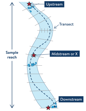
- Fish and macroinvertebrates are monitored within a sample reach, which is a length of stream equal to 35x the average width of the stream. The minimum reach length is 150m and the maximum is 500m.
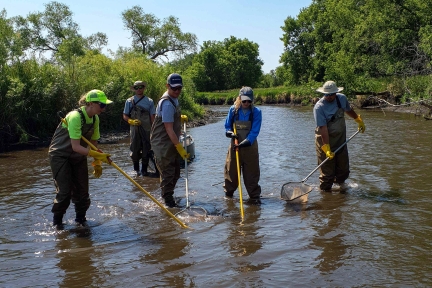
- Fish are sampled using either backpack, canoe-mounted, or boat-mounted electroshocking equipment depending on the size of the stream and whether it can be waded.
- Aquatic macroinvertebrates are collected using a D-frame dipnet from any wood, rock, bank, or aquatic plant habitat types present within the sample reach. Samples are field-preserved and later sent to a laboratory for identification.
- Habitat is characterized using the MPCA’s Stream Habitat Assessment (MSHA) as well as through a quantitative habitat evaluation which employs 13 evenly spaced, cross-sectional transects.
- Photo-documentation occurs during each monitoring visit with photos taken looking upstream and downstream at the downstream (DS), mid (X), and upstream (US) locations of the sample reach.
About the network
- station network established in 2013
- currently 68 stations in network
- about half of network sampled each year
- ecological condition ranges from minimally disturbed to best available
- stations paired with continuous flow monitoring where possible
- most stations located on public property to facilitate long-term access