The Rainy River - Headwaters Watershed covers 1,890,689 acres. 3,531 lakes represent 267,654 of the watershed’s acreage and wetlands represent another 362,218 acres. The watershed starts in northern Cook and Lake Counties and flows west and northwesterly into St. Louis County and the Canadian border waters and Basswood Lake and the Rainy River. There are no large cities in this remote watershed. The total watershed population is 6,784 (fewer than three people per square mile). Ely (population 3,841) is the largest city within the watershed borders, and nearby Winton has just 158 residents.
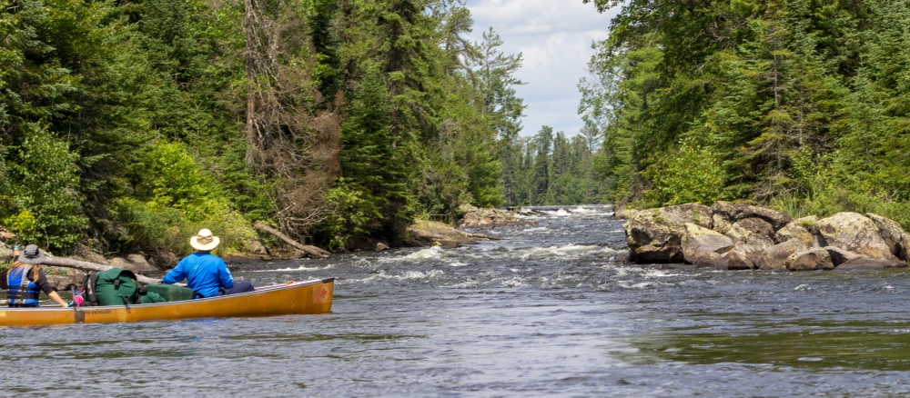
This watershed’s upper two-thirds is in the Border Lakes ecological sub-region and the lower third is in the Laurentian Uplands. The majority of this watershed is within the Boundary Waters Canoe Area Wilderness (BWCAW) and Voyageurs National Park. This area features boreal forest on shallow soils over bedrock. The BWCAW and Voyageurs National Park are roadless, undeveloped country that is interconnected with lakes and rivers. No motors are allowed in the BWCAW which makes it uniquely suited to canoe and kayak travel with portages and some long hiking trails.
Wilderness recreation and national park tourism are the prime economic drivers due to the scenic beauty, camping, and fishing opportunities. The Superior National Forest is also part of this watershed. Federal lands make up over 90% of this watershed.
Logging occurs outside the BWCAW and the national park. Some mining activity has occurred in the southern area. Additional lands are currently being explored for mining.
Lakes and streams in the watersheds bordering the Boundary Waters Canoe Area in northern Minnesota offer some of the most pristine water quality in the state. Protection strategies such as forestland conservation, protective shoreline buffers, proper culvert installation, and septic system maintenance will be crucial to maintaining their healthy conditions, according to two draft reports by the MPCA.
Excellent water quality in the Vermilion River and Rainy River - Headwaters watersheds is attributable to the forests and wetlands that dominate the area. They absorb and filter precipitation, resulting in far less runoff carrying pollutants into lakes and streams.
“The rivers and lakes in these watersheds are some of the cleanest waters in the state,” says Katrina Kessler, MPCA assistant commissioner for water policy and agriculture. “That’s why it’s so important that we focus not only on restoring waters that don’t meet water quality standards, but also protecting lakes and streams from becoming impaired in the first place. That’s especially true for areas like the Boundary Waters that are enjoyed and treasured by so many residents and visitors.”
The MPCA and local partners found that the vast majority of streams in the two watersheds meet water quality standards designed to protect fish and other aquatic life; nearly all lakes meet standards for swimming and other recreation. Several streams harbor exceptional fish and bug communities, an important indicator of excellent water quality. Only a few waters failed to meet water quality standards.
In the Rainy River - Headwaters Watershed, the MPCA studied 62 stream sections; ninety-seven percent fully support fish and other aquatic life and all but one lake assessed met the standards for recreation. More than 99 percent of the watershed is undeveloped and used both for timber production, and for hunting, fishing, hiking, and other recreation.
With minimal water quality problems, the WRAPS reports are focused on protection strategies. A core team representing local, state, tribal, and federal agencies met to guide assessments, investigate problems, and develop strategies to protect surface water for drinking, swimming, and aquatic life and discuss ways to ensure the watershed remains pristine. Local water managers, such as soil and water conservation districts, are particularly focused on managing lakeshore development that could degrade the currently healthy conditions. Healthy buffers and septic system maintenance can be implemented in these localized areas of shoreline development. Focus is on waters with degrading water quality and waters nearly impaired.
Monitoring and assessment
Since 2005, the MPCA began working with volunteers from the White Iron Chain of Lakes Association (WICOLA) to monitor four of the lakes in the Kawishiwi River system using the protocols of the Clean Lakes Monitoring Program Plus.
In 2010, WICOLA applied for a state Clean Water Legacy Act grant with Lake County serving as the fiscal agent. They were awarded a $225,000 grant and another Clean Water Partnership grant for $174,500 in early 2011. These grants have expanded water quality monitoring through more of the watershed. This research and monitoring for water quality, invasive species, failing septic systems, and sensitive areas, has provided information for outreach to partners and citizens, and ultimately produced a watershed management plan for the Kawishiwi portion of the Rainy River Headwaters.
Intensive watershed monitoring in this watershed began in 2016.
Supporting report
Strategy development for restoration and protection
- (EPA approval 7/20/2022)
- (MPCA approval 6/15/2022)