The Freeway Landfill and the Freeway Dump accepted waste before current landfill design standards were in place. There are a number of environmental concerns associated with both sites, including the potential for groundwater contamination, that need to be addressed to protect human health and the environment.
In October 2025, the MPCA took legal action against the owners of the facilities to protect drinking water for nearby Burnsville and Savage.
Health and environmental concerns
The two sites together contain over 6 million cubic yards of waste over 174 acres. Waste disposal occurred at the Freeway Dump from 1960 to 1969 and at the Freeway Landfill from 1969 to 1990 without the needed protections modern landfills have, including a liner beneath the waste and a system of pumps to collect and remove leachate that drains from the waste.
Environmental investigations suggest that the material in both sites consists of municipal solid waste (MSW) and construction and demolition (C&D) debris with pockets of coal ash industrial waste in the dump.
Regular testing shows drinking water supplies are meeting drinking water standards. However, the landfill and dump pose a threat to the Minnesota River and to the drinking water supply of Burnsville and Savage. The nearby Kraemer Quarry pumps water out of its pits, which keeps groundwater levels at the site artificially low. Once quarry pumping stops, projections show that groundwater levels will eventually rebound to natural conditions.
When those levels rise, the groundwater will come into direct contact with chemicals and other substances from the waste, causing additional contamination. The contaminated groundwater under the landfill will flow toward the Minnesota River, the lake that will form in Kraemer Quarry when the quarry eventually fills with water, and drinking water sources for the cities of Savage and Burnsville.
In addition, when waste decomposes, it can also create several types of air pollutants. The primary concern is the generation of methane, which can be explosive at certain concentrations. Methane also contributes to climate change when released into the atmosphere.
Our role
The MPCA operates the Closed Landfill Program to protect human health and the environment from contaminated fluids and gases that older, inactive landfills produce. The program determines what contamination exists at closed landfills, monitors groundwater near closed landfills, mitigates drinking water and indoor air impacts from closed landfills, and ensures systems are in place to remediate closed landfills.
After multiple attempts to bring the Freeway Dump and Freeway Landfill into the Closed Landfill Program, the MPCA took legal action in October 2025 by filing for a declaratory judgment. This will determine the legal rights and obligations of the MPCA and the owners of the Freeway Dump and Freeway Landfill under the Closed Landfill Program.
Location
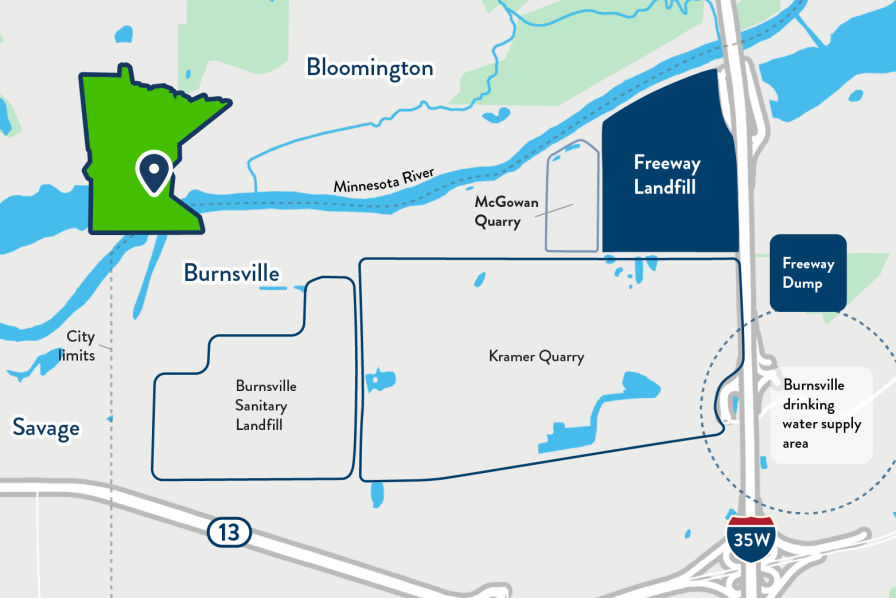
Both the Freeway Dump and the Freeway Landfill are located along Interstate 35W south of the Minnesota River in the city of Burnsville.
The 28-acre Freeway Dump has a vegetated soil cover and is currently used as a golf driving range. The waste footprint of the Freeway Dump extends past the property boundaries and covers approximately 34 acres. The estimated volume of waste in the Freeway Dump is 790,000 cubic yards.
The 140-acre Freeway Landfill is located between the Minnesota River and the Kraemer Quarry and contains 5.31 million cubic yards of waste. A portion of the site is currently used as a transfer station and the landfill no longer accepts waste for disposal.
Before the landfill began operating, this area was a floodplain with wetlands and agricultural fields. While a landfill would never be sited in that type of area today, it was not a prohibited land use at that time.
Project information
Groundwater contamination
A network of groundwater monitoring wells has been installed around both the Freeway Landfill and Freeway Dump to investigate the presence and movement of groundwater contamination. The sampling results show that groundwater contamination is widespread within the waste footprints, and recent testing shows that the contamination has migrated beneath and outside of the waste footprint. At many locations sampled, this contamination has been detected at levels exceeding regulatory criteria. The most common contaminants include heavy metals and chemicals of emerging concern like per- and polyfluoroalkyl substances (PFAS) and 1,4-dioxane, though many other contaminants were also detected.
The current groundwater pumping operations at the Kraemer Quarry are preventing contaminated groundwater from impacting the cities of Burnsville and Savage's drinking water wells. Tests from those wells have not detected contamination above regulatory standards.
MPCA environmental investigations have found contamination related to both the Freeway Landfill and Freeway Dump. The most recent investigation was a focused remedial investigation conducted in accordance with the EPA Superfund process. This investigation was conducted in two phases in 2018 and 2019.
Cleanup proposals
The MPCA presented two options to clean up the contamination in the spring of 2020 and released technical specifications for the options in 2021. The MPCA continues to consider both options viable.
Option 1: "Dig and line” would involve digging up the existing waste at the Freeway Landfill to allow a new modern landfill to be constructed on the site, then putting the waste back in afterward to encapsulate it. This option also includes moving the Freeway Dump waste to the new landfill. The Freeway Dump site may be available for reuse once the waste is removed.
There were three variations of this option developed. After evaluating the options and public comments, the MPCA selected a variation that balances the waste footprint size and the landfill height and offers a few notable benefits: It preserves the natural landscape of the Minnesota River valley, provides area for redevelopment along the Interstate 35W corridor, and offers greater flexibility if waste quantities vary during construction.
At the time, the estimated cost to build a new landfill on the property and replace the waste was around $117 million.
Option 2: “Dig and haul” would involve excavating the waste from the Freeway Landfill and Freeway Dump and hauling it to a different open, permitted landfill for final disposal.
At the time, the cost range of this option was $165 million – $538 million. This wide range is due to unknown waste disposal costs.
Next steps
The MPCA filed its legal action against the owners of the Landfill Freeway in Dakota County District Court and awaits the court’s decision.
More information
Frequently asked questions
- Is the drinking water safe in Burnsville and Savage?
Yes, the drinking water is safe today. The MPCA took the legal action to ensure that the groundwater, drinking water, and surface water nearby remains safe moving forward. The MPCA will continue to monitor water in the area.
- Why is it necessary to clean up the Freeway Landfill?
The two sites contain more than 6 million cubic yards of waste spread across 174 acres. Neither site has a liner, which means unhealthy levels of contaminants of concern (e.g., PFAS, 1,4 dioxane, volatile organic compounds, metals) could escape from the two sites. In the future, when Kraemer Quarry stops pumping, the groundwater flow will change, transporting contamination to the source of Burnsville and Savage’s drinking water and the Minnesota River. The drinking water for these cities currently does not exceed human health values.
- What action has MPCA taken?
The MPCA has initiated a declaratory judgment action against the owners of the Freeway Landfill.
- What will this declaratory judgment do?
A declaratory judgment action is a legal proceeding meant to resolve uncertainty about the legal rights of the parties to a controversy.
In this situation, the MPCA is asking a court to determine the rights and obligations for both the MPCA and the owners of the Freeway Landfill under the MPCA’s Closed Landfill Program.
This declaratory judgment is one step in a process that would eventually allow the MPCA to clean up the contaminated landfills rather than rely on the property owners to do so.
- Why did the MPCA file for a declaratory judgment?
The MPCA alleges that the owners of the two sites have either failed to take steps to remediate the property and complete closure activities or failed to allow the MPCA to remediate the property by entering into a binding landfill cleanup agreement with the MPCA under the Closed Landfill Program.
Project documents
Draft designs for the dig and line option
100% draft documents, not for construction.
Draft designs for moving the waste option
100% draft documents, not for construction.