With help from MPCA climate resilience grants, cities and watershed districts find solutions tailored to their needs
To cover Lafayette Park in Austin, Minnesota, with about eight feet of water seems unfathomable. The park sits on a broad plain devoid of much vertical rise — flat enough for a baseball diamond, softball field, and horseshoe pitch.
But in September 2004, when the city saw the worst flooding in its history, that’s just what happened. Cedar River, which cuts through the park, jumped its banks and crested nearly 10 feet above its flood stage. A blue square sign hangs from a telephone pole by the park’s entrance to mark how high the water rose.
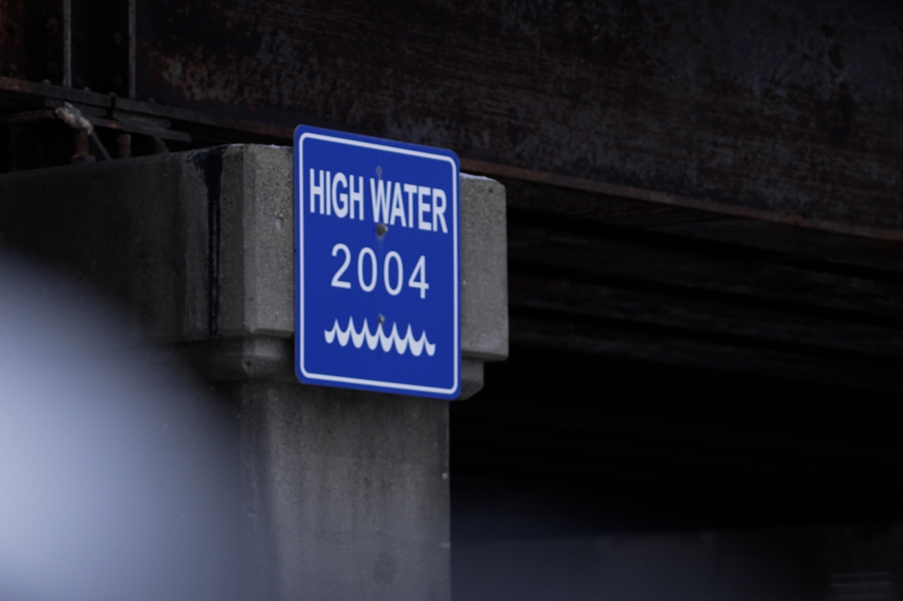
More blue signs across the city denote other high-water marks, serving as reminders of the record-breaking flood. Yet as climate change continues to cause extreme weather events in Minnesota and around the world, Austin and other Minnesota communities could see more high-water marks without flood-mitigation plans that account for climate change, including plans that the MPCA supported with a recent grant aimed at building climate resilience in Austin.
Old stormwater systems aren’t designed for climate change
Understanding climate resilience means first understanding what effects climate change will have on Minnesota. While winters have been warming here faster than the summers, the summers have been getting wetter.
At the most basic level, according to Linnea Savereide, an engineer in the MPCA’s stormwater section, “we’re expecting to see storms get more intense, which means more water that will come in a shorter amount of time which can overwhelm stormwater systems.”
According to an MPCA survey of Minnesota communities, 87% of local governments reported experiencing the effects of climate change, 54% reported more extreme rainfall and storms, and 33% have seen more frequent flooding.
Stormwater systems in use across Minnesota were often designed 50 to 100 years ago — even as far back as the 1800s, Savereide says — well before the extensive development some areas have seen in recent decades, which adds more impervious surfaces for water to drain from.

Those early stormwater systems also largely focused on channeling floodwaters as quickly as possible downstream and were designed well before the effects of climate change were fully understood. Brandon Smith, who supervises the MPCA’s stormwater research, engineering, and outreach unit, said that while many municipal stormwater systems were and continue to be designed using older forecast models like TP-40 and Atlas 14 that attempt to predict how much rain falls in a typical 10-year, 100-year, or even 500-year storm, “that information, which is based on how frequently areas have encountered that size storm in the past, doesn’t necessarily equate to what we’ll see in the future. What worked before is not the most effective way to address localized impacts.”
The National Oceanic and Atmospheric Administration, which issued Atlas 14 for the Midwest in 2013, is now in the process of updating its forecast models with a greater understanding of the impacts of climate change. In the meantime, however, communities across Minnesota are starting to realize that they’ll need more than just bigger pipes to handle those larger, less predictable storms. The same study mentioned above reported that one in four Minnesota communities do not have plans in place to address extreme weather caused by climate change.
“Each city is going to have different problems depending on its unique concerns and features,” Savereide said.
Perhaps nowhere is that more evident than Austin.
Flooding solutions from miles away
Since that 2004 flood, Austin has seen several changes meant to prevent that sort of flooding from occurring again. A decorative wall along a section of North Main Street can be converted into a floodwall within hours to prevent the Cedar River from inundating that section of town. And since 1978, the city has bought and relocated or demolished 240 houses in low-lying areas of the city that saw frequent flooding.
“We’ve got parks now where there used to be neighborhoods,” says David Simonson, a retired Austin police officer who responded to the 2004 floods and still lives just uphill of where those floodwaters reached. “Our whole neighborhood down here, everybody’s out. People learn it’s time to go.”
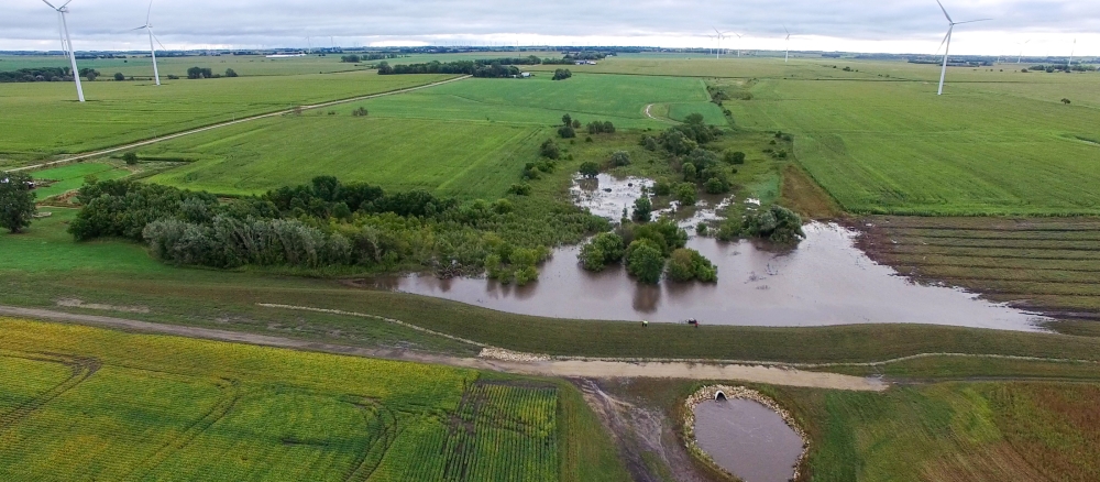
However, some of the more recent work to prevent waters from rising in Austin has taken place not in the city but miles away, amid the checkerboard of farm fields that surround the city, where windbreaks mark property lines and deep drainage ditches line both sides of dirt roads as straight as a fence line.
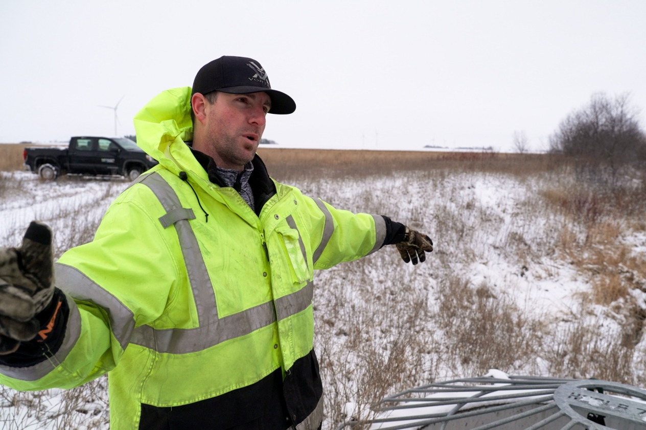
“People who don’t live here think it’s all flat,” says Cody Fox, the district administrator for the Cedar River Watershed District, “but we’ll see grades of 1% to 3%, which doesn’t sound like much, but it can really get the water moving fast.”
Because heavy clay underpins the soil in those fields, water from storms tends not to soak into the ground. Instead, it rushes through those drainage ditches and on into Dobbins Creek, Turtle Creek, and the Cedar River, which converge in Austin. Fox says rain from storms five miles out of Austin can make it into the city in just a matter of hours. “It moves that fast,” he says.
Without anything to slow that water, it can erode riverbanks, carry sediment far downstream, and overwhelm the pipes in Austin’s municipal stormwater system. That’s why Fox and his colleagues have spent the last several years developing a series of earthen berms in these rural areas meant to hold back heavy rains and meter out that water over the span of a couple days so all that extra water won’t inundate Austin.
The tallest of those berms stands 21 feet high and extends for a mile and a half across a tributary that feeds into Dobbins Creek. From the roads nearby, it blends into the landscape and becomes almost invisible, but up close it’s a towering structure, whipped at its peak by the same stiff breezes that turn nearby wind turbines.
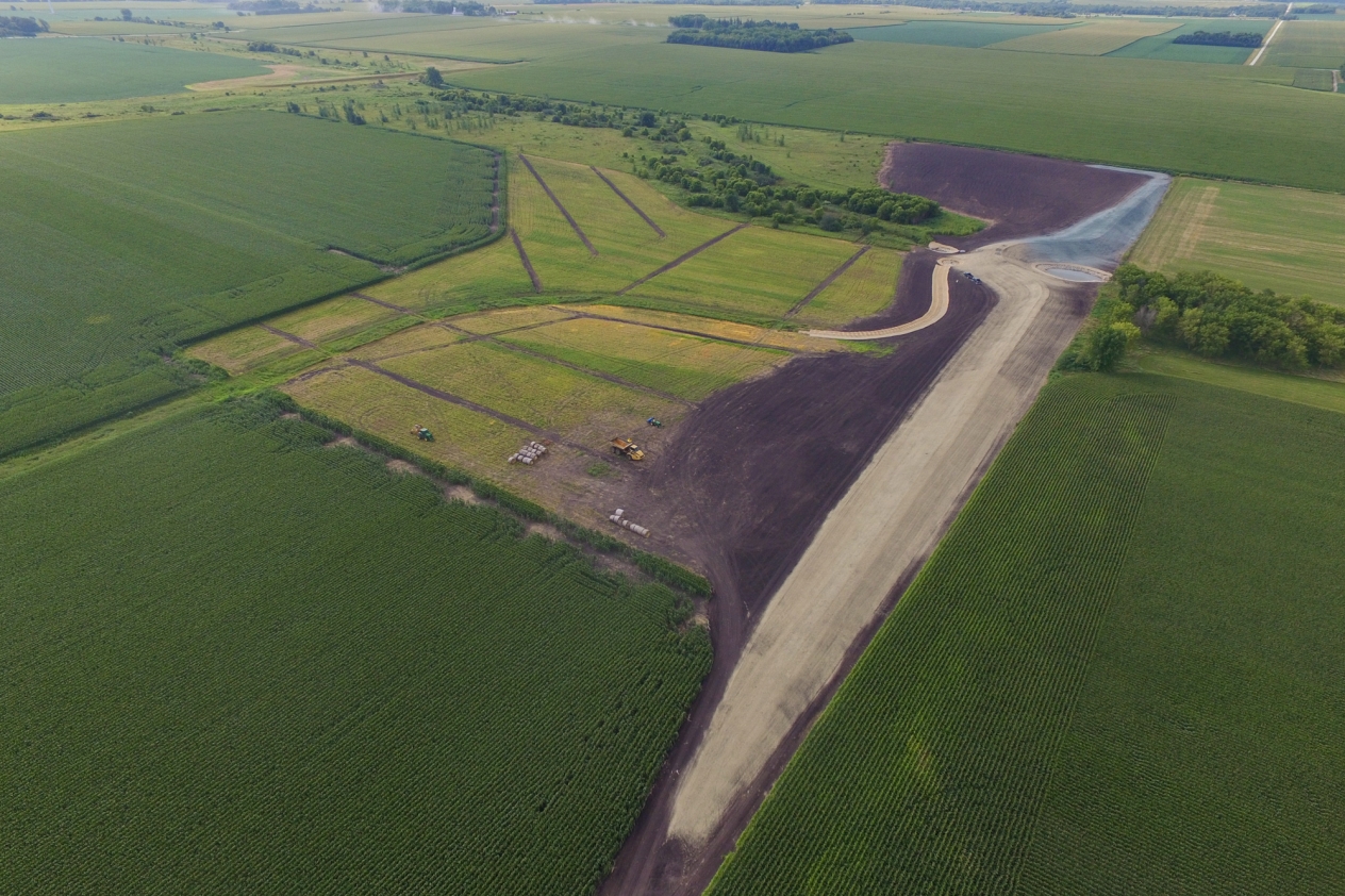
Normally, the water upstream of the berm trickles along, barely visible in a low-lying area of trees and grasses, but in storms the berm can store as much as 400 acre-feet — or about 130 million gallons — of water and release it downstream through an 18-inch pipe over one and a half to two days. On the downstream side, the water slows enough to saunter through existing drainage ditches without causing any damage.
“We’re not going to eliminate flooding overnight with the berms, but we can make some difference in a short amount of time,” Fox says.
Other berms throughout the watershed might not reach as high, but Fox says heavier rains brought on by climate change have led to taller berms than he initially thought.
“Ten years ago, we had a project that we figured needed a 10-foot berm to hold back a 100-year rain event of 5.8 inches,” he says. “But when updated forecasts put the 100-year rain event there at 7.8 inches, we needed to increase the height of the berm to 18 feet.”
Building these berms requires permanent easements and removing acreage from crop production, but Fox says they offer benefits beyond reducing downstream flooding, including the creation of wildlife habitat. “We’ll see deer and pheasants roaming through here where we didn’t see them before,” he says. “Some of the other berms are pastured to keep them from going totally out of production.”
How climate resilience grants help
So far, the Cedar River Watershed District has installed 16 berms out of the 50 or so that Fox expects will be needed to make a noticeable difference in Austin. Identifying which berms to build next, however, depends on multiple factors, including cost and cooperation from landowners.
“We acknowledge that farmers have put all this work in to drain their land over the last 100 years, and now we’re asking them to back it up again,” Fox says.
Building more berms also depends on which ones would offer the greatest impact, which is where the MPCA’s August 2022 grant to the district came in. The $78,000 grant, which came out of more than $3 million in funds dedicated to climate resilience planning in Minnesota, helped the district fund a study to determine exactly where more berms will be needed not only to reduce flooding in Austin but also to keep up with those heavier rains that climate change will bring.
“This grant points us in the right direction by helping to prioritize our list of projects,” Fox says. “We even learned from the study that putting one berm where we initially thought it might help would actually lead to an increase in flooding in Austin.”
Climate resilience grants are still relatively new to the MPCA, with the program kicking off in 2022. The initial rounds of grants have all funded planning projects, with the projects varying in nature from the creation of a “resilience hub” where people can shelter from flooding to more traditional infrastructure upgrades like bigger pipes.
While the Cedar River Watershed District tailored its approach to the area’s soil composition and geography, many of the climate resilience grants the MPCA has awarded so far similarly focus on diverting or metering out excess stormwater via retention ponds or cisterns built under streets and large parking lots. One approach even uses “smart pond” technology, in which sensors trigger pumps to empty out retention ponds ahead of large storms.
“We’re learning as we go,” Smith says. “We’re seeing more unique ideas for infrastructure. From the grants we’ve issued, we’ve gotten some valuable insight into what people want to focus their efforts on.”
These grants also mark the first time the MPCA has focused on stormwater quantity rather than quality in the form of treatment systems, though Smith and Savereide say that projects designed to divert or slow down excess stormwater often contribute to improved water quality by allowing sediment to settle out or by keeping runoff from parking lots from entering waterways.
Communities that have been awarded these grants are also well positioned for a new $35 million round of grants that will fund the construction of climate resilience projects like the Cedar River Watershed District’s berms. Communities need not have won a climate resilience planning grant from the MPCA to qualify for the construction grants, but projects do need to be based on a climate vulnerability assessment or stormwater modeling, Savereide said.
The climate resilience construction grants are open now through April 11. The MPCA will offer more climate resilience planning grants as early as late 2024.