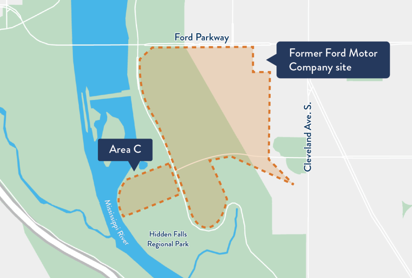
“Area C” is the name given to Ford Motor Company’s former industrial waste dump on the floodplain of the Mississippi River, at the base of the bluff below the former Twin Cities Assembly Plant in Saint Paul.
Our role
MPCA oversees Ford Motor Company’s environmental investigation at Area C, which includes evaluating the data against risk-based criteria and evaluating cleanup alternatives to address risk to people and the environment. MPCA staff will seek public input, and choose a cleanup plan for Area C.
Site history
From approximately 1945 through the mid-1960s, Ford disposed of paint sludge and solvents used in automobile painting operations at the base of the bluff. Although the specific disposal practices are not known, it appears that liquid solvents may have been dumped over the edge of the bluff, while barrels of paint sludge were buried. Disposal of industrial waste stopped in about 1966. Ford also disposed of construction rubble, contaminated soil, scrap metal, and other types of debris at Area C.
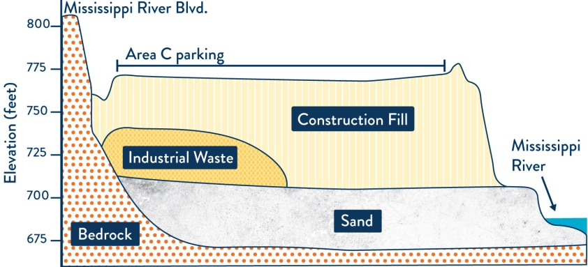
During the reconstruction of Lock & Dam No. 1 in the late 1970s and early 1980s, the U.S. Army Corps of Engineers disposed of a large volume of construction rubble and sand on top of and surrounding the industrial waste. In the mid-1980s, Ford covered the top of the construction rubble pile with a paved parking lot. The city of Saint Paul placed additional rubble at Area C during reconstruction of Mississippi River Boulevard in the late 1980s.
Groundwater samples were first collected from Area C in the late 1980s. No significant groundwater contamination was found; however, the investigation was limited, and the MPCA required a more thorough investigation of Area C as part of Ford Motor Company’s environmental assessment of its larger property after plant closure.
Where is the industrial waste?
Ford conducted an environmental investigation at Area C in 2015/2016, with results reported in the Area C – Comprehensive Site History and Investigation Report II (Arcadis, May 2017); this report is available on the city of St. Paul’s Ford Site Cleanup webpage.
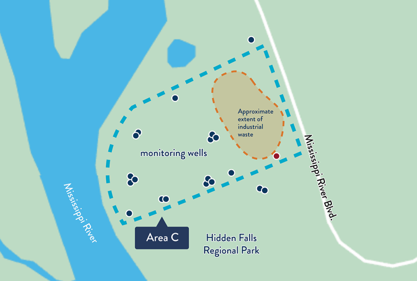
To determine the extent, depth, and thickness of the industrial waste, which is hidden by the overlying construction rubble and fill soil, 10 deep soil borings were drilled through the parking lot which covers Area C. Industrial waste was discovered beneath the eastern half of the parking lot (closest to the bluff). About 40 to 60 feet of fill soil is on top of the industrial waste.
What contaminants are in the industrial waste?
Samples of industrial waste collected from soil borings and test trenches contained solvents, metals, asphalt-related compounds, and polychlorinated biphenyls (PCBs), all related to Ford’s historical painting operations. The following metals were present at high concentrations in the industrial waste: antimony, arsenic, barium, cadmium, chromium, copper, lead, and zinc. Some samples of industrial waste were found to be hazardous with respect to lead.
The pollutants found in the industrial waste are there for a number of reasons:
- solvents found here were added to paint to make it easier to apply
- most of the metals found are associated with different colors of automobile paint from that era, with lead added to increase durability
- the earliest automobile paint (black) likely contained liquid asphalt
- PCBs may have been added to paint as a plasticizer, to minimize cracking
What contaminants are in the overlying soil?
Samples collected from the overlying construction fill identified isolated areas impacted by petroleum and asphalt-related contaminants associated with bituminous debris.
Samples of surface soil collected from the slopes of Area C contained low-level petroleum and asphalt-related contaminants, at concentrations typical of urban fill containing road rubble.
Is there groundwater contamination at Area C?
Twenty monitoring wells were installed around Area C between 2011 and 2020. The monitoring network allows collection of groundwater samples from three different depths. The shallow wells provide samples from the water table, mid-depth wells provide samples from deeper within the water table aquifer, and the deepest wells provide samples from the bedrock aquifer. The groundwater contamination has not spread far and the shallow groundwater contamination is not moving down into the bedrock aquifer.
Groundwater near the south slope of Area C has the greatest potential for contamination, due to the presence of paint sludge a few feet below the ground surface. Rainfall and surface water during floods sinks through the overlying soil in this area and can carry pollutants into the groundwater, particularly those associated with painting solvents and petroleum, since these contaminants move more easily through the soil. Metals tend to bind to the soil and don’t move as readily into the groundwater.
To determine if the groundwater contamination poses a risk to the Mississippi River, the concentration of pollutants in groundwater is compared to surface water standards that are applicable to the stretch of river near Area C. The evaluation also considers site-specific factors such as the volume of contaminated groundwater discharging to the river and the flow rate of the river.
In Area C groundwater, pollutants occur sporadically in time and/or location and do not indicate a significant plume of contaminated groundwater. The concentrations of pollutants in Area C groundwater are well below levels that pose a risk to the river.
Is the industrial waste in contact with groundwater?
The water table below Area C fluctuates in response to changing river conditions. Under normal river conditions, the water table is approximately five feet below the bottom of the industrial waste. To determine how groundwater below Area C interacts with the industrial waste during flood events, continuous water-level recording devices were installed in five monitoring wells. The water level data show that when the river level rises during flood events, the groundwater below Area C rises into the industrial waste (see Figure 3). This means that during a flood event, the lower portion of the industrial waste is saturated. As the river level drops, the groundwater below Area C also drops.
Groundwater samples have been collected from the monitoring wells at Area C shortly after flood events. No appreciable increase in contamination was detected in samples collected after the flood events.
Health assessment for Area C
The MPCA asked the Minnesota Department of Health (MDH) to do an independent review of potential risk to public health posed by the Area C dump.
- (2/11/2020)
MDH conclusions: “MDH concludes that there are only very limited ways that people can come into contact with the contamination at Area C. The presence of waste buried at Area C does not mean people have been or will be exposed to a health hazard. Our assessment found that minimal risks are possible if trespassers directly contact contaminants in shallow soils and physical hazards. Other exposure pathways were considered, but none were found to be complete.”
MDH recommendations:
- to discourage trespassing, consider repairing the fence and adding signage between the Hidden Falls Regional Park walking trail and the southern boundary of Area C
- consider removal of potential physical hazards and soil contamination from the southern slope
- continue monitoring the groundwater to demonstrate the ongoing negligible impact of any contamination moving from Area C to the Mississippi River via the groundwater pathway
The MDH document is an assessment of potential risk to people given the current condition of Area C. Members of the community who have expressed concerns about risk to public health may find the MDH document helpful. The absence of significant risk to public health under current conditions does not mean that no cleanup is warranted at Area C.
Site timeline
- 2015-2024 - Investigation: where is the contamination, what are the risks
- Oct. 2025 - Feasibility study presents 6 cleanup options
- Nov. 5, 2025-Feb, 3, 2026 - 90-day comment period on cleanup options
- Jan. 15 and Jan. 21, 2026 - Community meetings to discuss cleanup options
- 2026 - MPCA responds to public comment on cleanup options
- 2026 - MPCA selects cleanup plan and Ford develops design plan for implementation
- 2027 - Ford implements cleanup
Next steps for Area C
The MPCA has received the feasibility study for Area C from Ford Motor Company. This report examines a number of cleanup alternatives for this site, evaluating each using a required set of criteria. Refer to Table 5 in the report for a summary of the alternatives; the MPCA proposed plan for Area C is Alternative 4.
The MPCA hosted two community meetings, one in-person and one virtual, to provide background information on Area C, present an overview of the cleanup alternatives, and answer questions.
- Review the recorded online meeting from Jan. 21, 2026.
Review comments
The public comment period has closed for the feasibility study for Area C. The MPCA will respond to comments received in summer 2026.
Processes that lead to a cleanup decision
- investigation - where is the contamination, what are the risks?
- feasibility study - present cleanup options
- public notice - feasibility study and MPCA proposed plan
- community meeting
- revise feasibility study as needed
- MPCA selects final cleanup plan
- Ford implements cleanup
Evaluating cleanup options
- threshold criteria: overall protection of human health and the environment; compliance with applicable rules and regulation
- primary balancing criteria: long-term effectiveness and permanence; reduction of toxicity, mobility, or volume; short-term effectiveness; implementability; cost
- modifying criteria: community acceptance
After considering public comment, the MPCA will select a cleanup option in 2026. Ford will then develop a detailed plan for implementing the chosen cleanup option in 2026 and implement that plan in 2027.