Mississippi River — St. Cloud Watershed
Overview

Watershed at-a-glance
The Mississippi River - St. Cloud watershed covers 691,200 acres (1,080 square miles) in the south-central part of the Upper Mississippi River Basin. The watershed includes all or parts of Benton, Meeker, Mille Lacs, Morrison, Sherburne, Stearns, and Wright counties. Communities located in the watershed include Sauk Rapids, Elk River, Big Lake, Monticello, and parts of St. Cloud. The Mississippi River - St. Cloud watershed has 907 total river miles, and has 374 lakes with a total acreage of 23,728.
Monitoring and assessment reports
Mississippi River (St. Cloud) Watershed Monitoring and Assessment Report (wq-ws3-07010203b)
Water Quality Assessments of Select Lakes within the Mississippi River (St. Cloud) Watershed (wq-ws3-07010203)
| Hydrologic Unit Code (HUC) | 07010203 | [More Info] |
| Intensive monitoring start year | 2009 | [More Info] |
| Major lakes | Major rivers and streams |
|---|---|
|
Clearwater, Elk, Mink, Maple, Cedar, Sugar, Briggs Lake Chain, Lake Maria |
Mayhew Creek, Rice Creek, Clearwater, Elk, St. Francis River |
Characteristics
Within this watershed, the Mississippi River serves a multitude of uses. St. Cloud is the first city along the Mississippi River to obtain its drinking water from this resource. The river is also used by two of Minnesota’s most important power plants (Becker and Monticello) as a non-contact cooling water source.
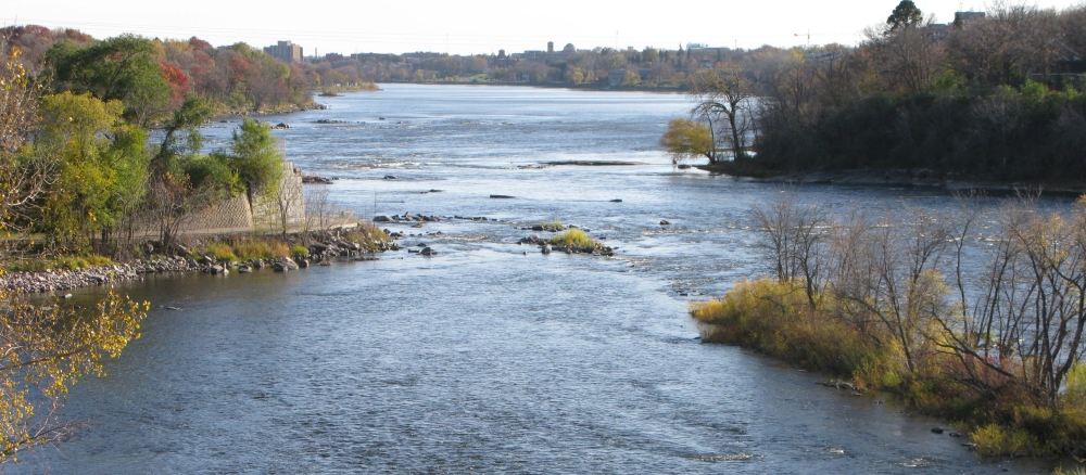
This stretch of the Mississippi River has been designated as a wild and scenic river. The rolling forested bluffs, numerous accesses and rest areas, along with abundant wildlife make this segment of the Mississippi River a popular route for day-long canoe trips. This portion of the river also provides excellent recreational fishing opportunities and is recognized for its high quality smallmouth bass fishing.
This watershed is on the fringe of the Twin City metropolitan area. In the recent past, during the height of the economy, significant residential development occurred within the watershed. In general, the water resources within this watershed tend to have intensively developed shorelines. Working to restore and protect the surface waters within this watershed through the implementation of best management rractices is critical to the overall environmental and economic health of the area.
The major threats to the watershed include:
- Loss of shoreline buffers and habitat due to development.
- Introduction of large amounts of phosphorus, sediment, and bacteria to surface waters.
- The combination of long, moderately steep slopes and easily erodible sandy loam soil that is inherently high in phosphorus.
- Increased nutrient, contaminant, and sedimentation loading from stormwater runoff from development and other non-point sources.
- Protecting drinking water supplies from bacteria impairments.
- Loss of biodiversity due to competition from invasive species.
- Relatively high percentage of agricultural and urban/residential land uses within the watershed.
What's being done
Intensive watershed monitoring (IWM) began in the spring of 2009 for the Mississippi River - St. Cloud watershed. An assessment report summarizing the biological monitoring and field data collected during the IWM process is scheduled to be completed in the spring of 2011. In 2010, major watershed restoration protection project work began to conduct a watershed-wide assessment and monitoring effort that will result in an implementation plan that will prescribe restoration and protection strategies for the surface water resources within the watershed.
Ongoing Total Maximum Daily Load (TMDL) projects within the watershed (e.g. Elk River Watershed Association TMDL and the Upper Mississippi River Bacteria TMDL) are continuing in accordance with their existing specific project work plans. The Elk River Watershed TMDL is scheduled for completion June 30, 2011. A watershed-wide assessment report of selected lakes will be completed in the spring of 2011. In addition, stream data within the watershed is currently being assessed with the assessment process scheduled to be completed in June 2011.
MPCA's watershed approach: Since 2007, the MPCA and its partners have begun implementing a 10-year rotation for watershed restoration plans to address Minnesota's waters at the major watershed level.

[+] See large map
Watershed News
New monitoring report available
In 2009, the MPCA began an intensive watershed monitoring effort of the Mississippi River (St. Cloud) Watershed’s surface waters. Fifty-two sites were sampled for biology at the outlet of variable sized sub-watersheds within the watershed. Read the results in the
Mississippi River (St. Cloud) Watershed Monitoring and Assessment Report.
Watershed project launch video now available
The MPCA and its partners have launched the Mississippi River-St. Cloud Watershed Project. Hear what living, working, and playing in this area means to some of the partners involved in this project, and enjoy nature's beauty throughout the watershed. Watch the video.
Stay connected
The Clearwater River Watershed District was formed 37 years ago and still works to improve water quality in the district. Read more in their spring newsletter.
Updates about the Mississippi - St. Cloud Watershed Project are available in the April issue of the Watershed Informant newsletter.
Check out the Mississippi River - St. Cloud Watershed Projects facebook page for news and events.


Restoration and protection
The restoration and protection process
The MPCA and partner organizations evaluate water conditions, establish improvement goals and priorities, and take actions designed to restore or protect water quality on a 10-year cycle.
Monitoring and assessment
Projects in this watershed to test water quality conditions and determine whether our lakes, rivers, and wetlands are meeting state water quality standards. [More info]
| Project Name | Status |
|---|---|
| Clearwater River Annual WQ Monitoring Program |
|
| Lake Orono Volunteer Monitoring |
|
| Minnesota Waters Citizen Monitoring |
|
| Mississippi River St Cloud Intensive Water Chem |
|
| Mississippi River-Saint Cloud Watershed Project |
|
| Sherburne County Lake Assessment Program |
|
| Stearns County Lake & Stream Monitoring Program |
|
| Upper Mississippi R Information Access Initiative |
|
| Wright County Citizens Lake Monitoring |
|
Reports
Data available for this watershed
Lakes and stream segments with condition and monitoring information
Lakes and streams are divided into "assessment units" for monitoring.
Impairments in this watershed listed by lake or stream segment
Generally, a waterbody has an impairment when it exceeds a particular pollutant standard.
Strategy development projects
Projects in this watershed that establish federal- or state-required plans for restoring water quality for impaired waters, or protecting high-quality waters. [More info]
Implementation activities
Projects in this watershed to put water restoration or protection measures in place, ranging from best management practices to reduce runoff from fields or streets, to fixes to wastewater treatment facilities, to education activities for citizens and landowners. Implementation projects are supported by local, state and federal government sources, including Minnesota's new Clean Water Fund.
Our partners in the watershed are continually involved in these kinds of activities. See Contacts tab.
| Project Name | Status |
|---|---|
| Clearwater River WSD Kingston Wetland Feasibility |
|
| Elk River Watershed Lakes Phosphorus Reduction |
|
| Lake McCarrons Subwatershed BMP Project |
|
| Stearns County Manure Basin Abandonment |
|
| Upper Mississippi River Source Water Protection |
|
Implementation plans
Contacts
Phil Votruba, MPCA project manager
218-316-3901
Phil.votruba@state.mn.us
Elk River Watershed Association
763-241-1170 ext. 3
http://www.sherburneswcd.org/ERWSA/ERWS.htm
Clearwater River Watershed District
320-274-3935
http://www.crwd.org/
Stearns Soil & Water Conservation District
320-251-7800, ext. 3
http://www.stearnscountyswcd.net/
Wright County Soil & Water Conservation District
763-682.1970 or 763-682-1933, ext. 3
http://www.wrightswcd.org/
Stearns County Environmental Services
320-656-3613
http://www.co.stearns.mn.us/Government/CountyDepartments/EnvironmentalServices
Sherburne County Planning and Zoning Administration
763-241-2900
http://www.co.sherburne.mn.us/zoning/index.php
Maps
Watershed Map
Many of Minnesota’s lakes and streams do not currently meet water-quality standards because of pollution such as excess sediment or nutrients, bacteria or mercury. These waters are considered “impaired.” For more information, visit the impaired waters page.
The toggles show impaired waters and monitoring stations. Click on a site for more information.
Impairments in this watershed, listed by lake or stream segment
Generally, a waterbody has an impairment when it exceeds a particular pollutant standard.


