Mississippi River - Lake Pepin Watershed
Overview

Watershed at-a-glance
The Mississippi River - Lake Pepin watershed includes 205,747 acres that drain several small, coldwater streams in bedrock-dominated bluff country. The largest of these streams is Wells Creek (45,954-acre watershed), which winds through 18 miles of bluff lands and joins the Mississippi near Old Frontenac, southeast of Red Wing. Hay Creek is a popular trout stream (30,405-acre watershed) that flows from south to north, joining the Cannon River bottoms at Red Wing. Three other named streams are all designated trout waters, and drain directly to the Mississippi River: Bullard Creek (10,245-acre watershed), Gilbert Creek (16,007-acre watershed) and Miller Creek (11,168-acre watershed).
The Vermillion River watershed encompasses 335 square miles in central Dakota County and extreme southeast Scott County, part of the Twin Cities seven-county Metropolitan area. The Vermillion River Main Stem flows 38 miles from the headwaters in New Market Township through Eureka Township, the city of Farmington, Empire and Vermillion Townships, and on to Hastings, where it discharges to the Mississippi River. Major tributaries to the Vermillion include South Creek, Middle Creek, and North Creek (winding through Lakeville and Farmington) and South Branch (through Castle Rock and Vermillion Township).
| Hydrologic Unit Code (HUC) | 07040001 | [More Info] |
| Intensive monitoring start year | 2008 | [More Info] |
| Major lakes | Major rivers and streams |
|---|---|
|
There are no major lakes in the watershed; however the watershed is adjacent to Lake Pepin. |
Vermillion River, Wells Creek, Hay Creek, and other small streams which drain directly to the Mississippi River. |
Characteristics
The Mississippi River - Lake Pepin watershed consists of forests, bluff lands, and cultivated lands. The top of the watershed is rolling cropland interspersed by many small tributaries that drop steeply through forested valleys with scattered goat prairies atop cliffs. The tributaries join to form the named streams, which drain directly into the Mississippi River. The watershed is only about 50 miles southeast of downtown St. Paul. As a result, the watershed is subject to development pressures.
Agriculture is the primary land use in the watershed (approximately 70%). About 10% of the land is in grass. Corn and soybeans make up over half the tilled acreage of the area, with barley, oats and pasture land present. Forage production is strong because of the large number of dairy cows in the region. Of the grassland, 90% is in pasture and a small percentage (<10%) is in a management intensive rotational grazing system. Most of the remaining acreage is deciduous forest. Frontenac State Park, Lake Pepin, and the coldwater fisheries are significant natural resources that provide recreation and revenue in the region.
Vermillion River
The Vermillion is a slow-flowing prairie river, making its way through agricultural, suburban, and small urban areas. Approximately 49 miles of the Main Stem and tributaries on the western half of the river are Minnesota Department of Natural Resources Designated Trout Streams.
The watershed is within the Western Corn Belt Plains ecoregion. The northwestern portion of the Watershed is located in the Eastern St. Croix Moraine, and the southwestern portion of the watershed is located in the Prior Lake Moraine. Moraines are masses of rocks, gravel, sand, clay, etc. carried and deposited directly by glaciers). The Eastern St. Croix Moraine and the Prior Lake Moraine mark the limit of the former Superior Lobe and Des Moines Lobe, respectively (lobes are finger-shaped glaciers that develop at the edge of continental ice sheets). Moraine areas consist of rolling to steep hills and closed depressions where lakes and wetlands are common. The sediments of moraine areas are a complex assortment of till (a mixture of sand, silt, clay, pebbles, cobbles, and boulders), silt and sand lenses, and sand and gravel deposits. The till of the Superior Lobe is red and has a coarse texture (sandy loam). The till of the Des Moines Lobe is gray to yellowish brown and has a fine texture (loam).
The bedrock units underlying the watershed are sedimentary rocks (formed by the deposit of sediment) of marine origin. The Watershed is on the southeastern edge of the Twin Cities Basin and the rock in the watershed dips toward the north and west. The dominant structural features in the watershed associated with the Twin Cities Basin are the Vermillion Anticline (a fold, convex upward) and the Empire Fault. Both the anticline and the fault are oriented geographically from the northeast to the southwest almost parallel to the course of the modern Vermillion River. These structural features are not expressed on the land surface, but can be seen in bedrock outcrops along the Mississippi River bluffs above the city of Hastings.
The predominant land use pattern in the watershed is agriculture, interspersed with suburban areas and smaller urban growth centers. Growth in the area has resulted in increased urbanization of the northwest portion of the Watershed. Parts of Burnsville, Apple Valley, Rosemount, Lakeville, and Farmington have dense residential, commercial, and industrial land use. All of Burnsville and Apple Valley and portions of the other four cities are included in the Metropolitan Urban Service Area (MUSA). As such, metropolitan services and facilities are or will be provided. Areas of urban growth beyond the MUSA boundary are evident in Lakeville, Farmington, and Hastings. Local controls in these cities provide planned growth in an effort to ensure the compatibility of land use types and the efficient use of public services and facilities.
What's being done
The MPCA is planning to work with local partners to:
- Further understand the biology of Wells Creek. Intensive watershed monitoring (IWM) was completed in 2008. Follow-up monitoring and stressor identification are subsequent steps in a comprehensive approach to understand Wells Creek and its watershed.
- Understand the complexity of the karst geology, which underlies much of the Wells Creek watershed. In karst, surface water and groundwater interchange regularly. Water flowing on the surface may suddenly drop into a sinkhole and then re-emerge a few miles downstream as a spring out of the limestone to rejoin the surface water. Because groundwater is used as a primary drinking source in the area, it is especially important to exercise caution when applying anything to the surface.
- Empower the relatively small population of approximately 1,500 people in a watershed of 40,172 acres to implement best management practices to reduce pollutants.
- Protect the diverse landscape of the watershed, which varies from rich farmland to karst features to bluffs with dramatic valleys. Ensuring that aquatic life and aquatic recreation are protected is important to the economy of the watershed.
MPCA's watershed approach: Since 2007, the MPCA and its partners have begun implementing a 10-year rotation for watershed restoration plans to address Minnesota's waters at the major watershed level.

[+] See large map
Watershed News
Is Minnesota's water quality important to you?
If so, take this quick survey. Less than 5 minutes of your time will help us give you the information you want about Minnesota's water quality.
New reports available
The Mississippi River Lake Pepin Watershed Monitoring and Assessment Report was recently completed and is now available.
The Vermillion River Watershed Monitoring and Assessment Report is now available, too!


Restoration and protection
The restoration and protection process
The MPCA and partner organizations evaluate water conditions, establish improvement goals and priorities, and take actions designed to restore or protect water quality on a 10-year cycle.
Monitoring and assessment
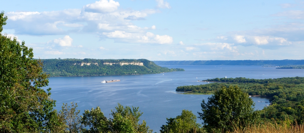
Projects in this watershed to test water quality conditions and determine whether our lakes, rivers, and wetlands are meeting state water quality standards. [More info]
| Project Name | Status |
|---|---|
| Butler Pond Monitoring Program |
|
| Citizen Sediment Monitoring Coordinator for TMDLs |
|
| Goodhue County Water Quality Monitoring |
|
| Lower Mississippi River Basin Long Term Monitoring |
|
| Lower Vermillion River Effectiveness Monitoring |
|
| Nitrate Data Tabulation and Lit Review |
|
| Nitrogen/Bacteria Monitoring Zumbro River |
|
| S.E. MN Volunteer Nitrate Monitoring Network |
|
| Sediment Work for LMB TMDL Support |
|
| Volunteer Nitrate Monitoring Network |
|
Data available for this watershed
Lakes and stream segments with condition and monitoring information
Lakes and streams are divided into "assessment units" for monitoring.
Impairments in this watershed listed by lake or stream segment
Generally, a waterbody has an impairment when it exceeds a particular pollutant standard.
Strategy development projects
Projects in this watershed that establish federal- or state-required plans for restoring water quality for impaired waters, or protecting high-quality waters. [More info]
| Project Name | Status |
|---|---|
| Credit River Turbidity TMDL Development |
|
| Lake Pepin Nutrients TMDL |
|
| Lake St. Croix TMDL |
|
| Long and Farquar Lakes (Metro) |
|
| Lower Cannon River Turbidity TMDL |
|
| Lower Mississippi River Basin-Fecal Coliform TMDL |
|
| Lower Vermillion River Watershed Turbidity TMDL Project |
|
| Mercury Pollutant Reduction Plan |
|
| Mississippi River - Lake Pepin Major Watershed WRAP Strategy |
|
| South Metro Mississippi TSS |
|
| Vermillion River Watershed Joint Powers Organization WRAP Strategy |
|
Implementation activities
Projects in this watershed to put water restoration or protection measures in place, ranging from best management practices to reduce runoff from fields or streets, to fixes to wastewater treatment facilities, to education activities for citizens and landowners. Implementation projects are supported by local, state and federal government sources, including Minnesota's new Clean Water Fund.
Our partners in the watershed are continually involved in these kinds of activities. See Contacts tab.
| Project Name | Status |
|---|---|
| Chloride Winter Maintenance Trng & Certification |
|
| Dakota County NPS Reduction |
|
| Fecal Coliform Bacteria TMDL Implementation |
|
| Feedlot Fixes Cost-share Incentives |
|
| Feedlot Open Lot Implementation Engineer Assist |
|
| Livestock Management Improvements Riparian Areas |
|
| Lower Miss/Cedar River Unsewered Assist |
|
| Lower Mississippi Basin SE MN Wastewater Initative |
|
| Lower Mississippi Feedlot Runoff Control |
|
| Southeast Regional Grant for Water Quality SE |
|
| Sustaining Progress Toward Reducing Runoff |
|
| Vermillion River & Chub Creek ISTS Program |
|
Implementation plans
Contacts
Justin Watkins, MPCA project manager
18 Wood Lake Dr SE
Rochester, MN 55904
507-206-2621
justin.watkins@state.mn.us
Brooke Asleson, Vermillion River-MPCA Coordinator
651-757-2205
brooke.asleson@state.mn.us
Goodhue County SWCD
104 E 3rd Ave
PO Box 335
Goodhue, MN 55027
651-923-5286
Vermillion River Watershed Joint Powers Organization
14955 Galaxie Avenue
Apple Valley, MN 55124
http://www.vermillionriverwatershed.org/
Wabasha County SWCD
611 Broadway Ave, Suite 10
Wabasha, MN 55981
651-565-4673
Wells Creek Watershed Partnership
Maps
Watershed Map
Many of Minnesota’s lakes and streams do not currently meet water-quality standards because of pollution such as excess sediment or nutrients, bacteria or mercury. These waters are considered “impaired.” For more information, visit the impaired waters page.
The toggles show impaired waters and monitoring stations. Click on a site for more information.
Impairments in this watershed, listed by lake or stream segment
Generally, a waterbody has an impairment when it exceeds a particular pollutant standard.
Twin Cities Metro Watersheds
Twin Cities Metropolitan Area Watersheds
The seven-county TCMA includes the counties of Anoka, Carver, Dakota, Hennepin, Ramsey, Scott, and Washington. The TCMA watersheds also contain the area covered by the Metropolitan Area Surface Water Management Act (Minnesota Statutes 103B.201 to 255), which requires local units of government in the seven-county TCMA to prepare and implement comprehensive surface water management plans through membership in a watershed management organization (WMO). WMOs can be organized in three ways:
- as a joint powers agreement between the cities and townships within the watershed.
- as a watershed district.
- as a function of county government.
Most WMOs boundaries are hydrologically defined, and are at the 10- or 12-digit hydrologic unit code (HUC) sub-watershed level. Some WMO boundaries are politically determined rather than hydrologically determined.
Projects may involve small portions of local or watershed plans such as neighborhood stormwater projects, be city- or watershed-wide projects to deal with identified impairments, or be regional or basin-wide projects dealing with problems such as chloride runoff in the TCMA watersheds from highway road salt or basin-wide runoff of nutrients affecting Lake St. Croix.
Additional information is also available on the Twin Cities Metropolitan Area Watersheds page.


