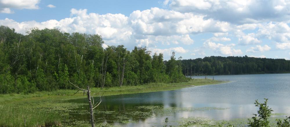
http://www.pca.state.mn.us

tinyURL : oxpgdee | ID : 2852Home   >   Water   >   Water Types and Programs   >   Watersheds

main content

Leech Lake River Watershed

Overview


[[photo_credit]]

Watershed at-a-glance

The Leech Lake River watershed consists of approximately 854,659 acres (1,335 square miles) in the northernpart of the Upper Mississippi River Basin. The watershed includes parts of Beltrami, Cass, and Hubbard counties. Major communities in the watershed are Laporte, Benedict, Walker, Federal Dam, Boy River, Whipholt, Longville, and Hackensack. The watershed also includes the Leech Lake Reservation (Leech Lake Band of Chippewa). The Leech Lake River watershed has 277 total river miles and contains over 750 lakes with a total acreage of 166,374.


Hydrologic Unit Code (HUC) 07010102 [More Info]

Intensive monitoring start year 2012 [More Info]

Major lakesMajor rivers and streams

Boy, Woman, Child, Girl, Kabekona, Inguadona, Leech, Sixmile, Tenmile, Steamboat

Boy, Kabekona, Leech Lake River, Little Boy, Mud, Sixmile Brook, Steamboat


Characteristics

The Leech Lake River watershed is located in the Northern Lakes and Forest ecoregion of Minnesota. This watershed is largely forested, with about 46% of the land privately held, with remaining portion of land county or federal public land, or held by tribal land owners.

This watershed is situated in the heart of Minnesota’s lake country and contains some of the most pristine natural resources in Minnesota. This watershed has a very high degree of biodiversity in its thousands of acres of forests and surface waters.  One-half of Minnesota’s naturally producing Muskie lakes and a quarter of the natural Muskie habitat in the United States is located in the Leech Lake River watershed. Forests in the watershed boast the largest number of breeding eagle pairs in the lower 48 states, as well as many other healthy wildlife populations. The State Action Plan for Minnesota Wildlife identified 89  “species of greatest conservation need,” including 29 species that are federal or state endangered, threatened, or of special concern within the watershed.

Currently, the surface water resources within this watershed meet Minnesota’s surface water quality standards for conventional pollutants (not including mercury).  However, these resources are experiencing increased pressure from development and subsequent loss of shoreline and aquatic habitat. The surface water resources within this watershed are highly prized for their recreational value and these resources attract several thousand vacationers to the area each year. The protection of these resources is vital in sustaining the natural heritage and character of this watershed. 

The major threats to the watershed include:

  • Loss of shoreline and aquatic habitat due to development.
  • Population growth of up to 60% projected for the watershed by 2030, according to Minnesota State Demographers.
  • Increased nutrient, contaminant, and sedimentation loading from stormwater runoff from development and other non-point sources.
  • Loss of biodiversity due to competition from invasive species.

What's being done

Several lake associations/citizens throughout the watershed actively participate in water quality monitoring through the Citizen Lake Monitoring Program. In an effort to fill lake data gaps, Cass County Environmental Services (CCES) and Hubbard SWCD are monitoring several lakes in the watershed through grants and local water plans. Several partners within the watershed have also worked together to identify sensitive shoreland areas on large lakes in the in Cass County. These sensitive shoreland areas will be evaluated for zoning re-classification to Resource Protection Districts. 

In addition, the Leech Lake Area Watershed Foundation successfully continues toward its mission to fund, promote, and enable activities that will protect the natural environment of the Leech Lake Watershed. Through their efforts numerous conservation practices have been implemented since 1997, including preserving and protecting over 15 miles of wild shoreline.

In preparation for MPCA’s 2012 intensive watershed monitoring effort for this watershed, field reconnaissance will be done on stream monitoring sites in the fall of 2011. The MPCA will begin the planning efforts with local partner groups in the summer of 2011 for the major watershed restoration and protection project, with a watershed kickoff meeting tentatively scheduled for the spring of 2012. Citizens interested in getting involved with the project can contact the MPCA project manager

MPCA's watershed approach: Since 2007, the MPCA and its partners have begun implementing a 10-year rotation for watershed restoration plans to address Minnesota's waters at the major watershed level.

[+] See large map


Watershed News

Is Minnesota's water quality important to you?

If so, take this quick survey. Less than 5 minutes of your time will help us give you the information you want about Minnesota's water quality.

Minnesota water stories

In communities throughout Minnesota, MPCA staff, along with other government agencies and citizen groups, are working to protect and restore the water quality of our rivers, lakes, and streams. Learn more about these efforts.

Preventing runoff

Find out how keep our lakes and rivers clean by capturing rainwater in your yard.

WaterFront Bulletin

WaterFront Bulletin: Find out about updates on impaired waters, watershed project funding, and water restoration and protection activities underway throughout the state.


Restoration and protection

The restoration and protection process

The MPCA and partner organizations evaluate water conditions, establish improvement goals and priorities, and take actions designed to restore or protect water quality on a 10-year cycle.


  Monitoring and assessment

Projects in this watershed to test water quality conditions and determine whether our lakes, rivers, and wetlands are meeting state water quality standards. [More info]

Project Name Status    
Cass County Citizens Lakes Monitoring
Hubbard County Citizens Lake Monitoring
Upper Mississippi R Information Access Initiative
Whitefish Chain and Surrounding Lakes


Data available for this watershed


Lakes and stream segments with condition and monitoring information
Lakes and streams are divided into "assessment units" for monitoring.

Impairments in this watershed listed by lake or stream segment
Generally, a waterbody has an impairment when it exceeds a particular pollutant standard.


  Strategy development projects

Projects in this watershed that establish federal- or state-required plans for restoring water quality for impaired waters, or protecting high-quality waters. [More info]

Project Name Status    
Leech Lake River Major Watershed WRAP Strategy
Mercury Pollutant Reduction Plan


  Implementation activities

Projects in this watershed to put water restoration or protection measures in place, ranging from best management practices to reduce runoff from fields or streets, to fixes to wastewater treatment facilities, to education activities for citizens and landowners. Implementation projects are supported by local, state and federal government sources, including Minnesota's new Clean Water Fund.

Our partners in the watershed are continually involved in these kinds of activities. See Contacts tab.

Project Name Status    
Upper Mississippi River Source Water Protection


Water data tools

Search for your lake or stream's assessment data
See information about your local lake or stream.


DNR Lake Finder
Find information about 4500+ lakes, rivers, and streams


Search MPCA surface water data
Use this tool for accessing and comparing data in all surface waters.


Contacts

Phil Votruba, MPCA project manager

218-316-3901
Phil.Votruba@state.mn.us


Maps

Watershed Map

Many of Minnesota’s lakes and streams do not currently meet water-quality standards because of pollution such as excess sediment or nutrients, bacteria or mercury. These waters are considered “impaired.” For more information, visit the impaired waters page.

The toggles show impaired waters and monitoring stations. Click on a site for more information.

Impairments in this watershed, listed by lake or stream segment
Generally, a waterbody has an impairment when it exceeds a particular pollutant standard.


Last modified on November 28, 2011 13:31

additional content