The MPCA is collaborating with many federal, Tribal, state, and local partners to clean up sites in the Duluth harbor and St. Louis River that are contaminated from a century of industrial and shipping activities. The sites are part of an Area of Concern (AOC), one of 43 such areas in the Great Lakes region designated by the U.S. and Canadian governments, that show signs of significant environmental harm from local causes. The St. Louis River Area of Concern (SLRAOC), which encompasses parts of Minnesota and Wisconsin, is the second largest AOC in the U.S.
A legacy of environmental harm
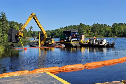
Before there were environmental regulations, wetlands and other aquatic habitat around the Duluth Harbor could be dredged to create anchorage slips for ships or filled in to make land for development. In addition, cities, industries, and businesses discharged their waste directly to the St. Louis River without treatment. Mercury and other metals, dioxins and furans, polychlorinated biphenyls (PCBs), polycyclic aromatic hydrocarbons (PAHs), and other toxins in these discharges eventually settled in the sediment at the bottom of the river.
Early environmental regulations, such as the Clean Water Act, only applied to ongoing activities, not the legacy of contamination and lost habitat from previous years. The AOC program was created to address legacy effects in the Great Lakes region.
The problems
The 1987 U.S.-Canada Great Lakes Water Quality Agreement that formed the AOCs identified 14 beneficial use impairments (BUIs) common throughout the Great Lakes. A BUI is a legal designation for a type of environmental degradation that affects how a natural resource can be used — thus, a "use impairment." Nine of the 14 identified BUIs applied to the St. Louis River AOC:
- Fish consumption advisories: Mercury and PCB contamination in the sediment affects fish; the public is advised to limit consumption of fish pulled from the river to avoid harmful health effects.
- Degraded fish and wildlife populations: Native fish and wildlife populations are limited by loss of habitat, food sources, and water quality, or contaminated sediments.
- Fish tumors and other deformities: The rate of tumors and deformities in bottom-dwelling fish exceeds the rate of these problems in uncontaminated areas of the Great Lakes.
- Degradation of benthos: The community of bottom-dwelling plants and animals (benthos) is significantly degraded compared to similar but uncontaminated sites in the AOC.
- Restrictions on dredging: Because of the toxins in it, sediment dredged from contaminated areas in the AOC has special handling requirements.
- Excessive loading of sediment and nutrients: Water suffers from excess levels of sediment and phosphorus, which can harm fish and other aquatic species and promote excessive algae growth.
- Beach closings and body contact restrictions: Disease-causing pathogens in the water from wastewater and stormwater make it unsafe for swimming and other recreational activities.
- Degradation of aesthetics: The persistent appearance of objectionable properties mars the body of water.
- Loss of fish and wildlife habitat: A significant amount of fish and wildlife habitat is degraded or destroyed.
Each BUI must be addressed in order to reverse the legacy problems.
The importance of restoration
As it nears Lake Superior, the St. Louis River forms a 12,000-acre estuary, where the river water mixes with lake water. Strong northeasterly winds can push enough lake water into the estuary to affect water levels up to 18 miles upstream! Besides affecting water levels, this lake-river push and pull reverses water flows, flushes sediments, adds oxygen, and releases nutrients, creating a unique, biologically productive area that is rich in plant and animal diversity. The estuary supports more than 230 species of migrating and nesting birds, and provides habitat for 45 fish species, including spawning and nursery habitat for some western Lake Superior fish. It contains most of Minnesota’s imperiled coastal marsh habitat, including stands of the state grain, wild rice, which is central to Ojibwe culture. Reversing the impairments caused by legacy problems will help restore the St. Louis River estuary ecosystem. In addition, formerly polluted areas are becoming more enticing for recreation, such as paddling, birding, and fishing, and for economic revitalization, such as the pockets of redevelopment happening in West Duluth.
More information
- Video: AOC 101 (Wisconsin Department of Natural Resources) - How the Great Lakes Area of Concern program is helping address legacy pollution
- Video: It takes a (shipping) village: Duluth's harbor springs to life - How the development of the Duluth harbor affected the St. Louis River, and the work to restore it
- Beneficial Use Impairment description (U.S. EPA)