High levels of suspended sediment flow through the Minnesota River and the South Metro portion of the Mississippi River. Excess sediment — primarily clay and silt — contributes to cloudy, murky water, which degrades habitat for fish and aquatic life, and lowers the aesthetic quality of our rivers for recreation and tourism.
The Minnesota Pollution Control Agency has developed a general strategy that focuses on strategies and actions that can be used to help achieve local sediment reduction goals. It acknowledges the complexity of land use and geographical issues facing sediment reduction goals.
Sediment reduction goals
The sediment reduction strategy proposes interim targets for the Minnesota River, including a 25 percent reduction by 2020 and a 50 percent reduction by 2030. While the 2020 target was not achieved, progress has been made thanks to the efforts of local resource professionals and watershed residents. The strategy also proposes meeting the Minnesota River sediment TMDL by 2040. This will require an overall sediment concentration reduction of approximately 80 percent. The south metro Mississippi River sediment TMDL requires a 50 percent reduction from current sediment loading.
Significant changes in policy, technology, and the science behind these issues are expected over the next 20 years. Because these changes may influence planning efforts in unforeseen ways, a focus on meeting shorter-term goals will help ensure that each step of the implementation process is based on current data and information.
The MPCA determined sediment reduction goals for the Minnesota River and the south metro portion of the Mississippi River from TMDL studies for sediment in the two rivers. The studies focus on achieving the level of sediment, or load, that the rivers can accept and still meet state water quality standards for aquatic recreation. The TMDLs are part of a nationwide effort under the federal Clean Water Act to identify and clean up pollution in streams, rivers and lakes. Following the studies, the MPCA works with local partners to develop plans to reduce the pollutants.
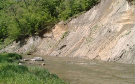
Sources of sediment
Because the majority of the suspended sediment load in the South Metro Mississippi River comes from the Minnesota River, efforts in the Minnesota River basin directly affect downstream areas. Sediment erosion in the Minnesota River Basin and its tributaries comes from four main sources:
- Bluffs and streambanks
- Uplands — surface erosion from areas of exposed soil
- Urban areas and other developed land uses
- Ravines and gullies
According to several scientific studies, the greatest contributors to increased sediment in the Minnesota River are ravines, bluffs and streambanks, often referred to as “near-channel sources.”
The sediment reduction strategy emphasizes the importance of citizen involvement in setting short- and long-term goals, tracking progress, and adapting to future research and monitoring.
Regardless of the main cause or causes, many of the solutions are the same. They can range from traditional conservation practices that reduce soil erosion on cropland, to innovative practices and programs that increase water storage on the land.